Information of accommodation in Shimanto City and Kuroshio town is packed!


Shimanto River & Its Sinking Bridges
![]() Mount Irazuyama is a 1,336-meter peak situated south-east of the Shikoku Karst Prefectural Nature Park, in Tsuno Town, Takaoka District, Kochi Prefecture. The most upstream section of the mountain's Irazu Valley is the source of the Shimanto River. On November 2nd 1987, the Higashi-Tsuno Village (now Tsuno Town) and Suzaki Branch of the Zenrinya forestry worker's union conducted a joint survey of the area, and commemorated this effort by erecting a sign in the valley at an elevation of 1,200 meters.
Mount Irazuyama is a 1,336-meter peak situated south-east of the Shikoku Karst Prefectural Nature Park, in Tsuno Town, Takaoka District, Kochi Prefecture. The most upstream section of the mountain's Irazu Valley is the source of the Shimanto River. On November 2nd 1987, the Higashi-Tsuno Village (now Tsuno Town) and Suzaki Branch of the Zenrinya forestry worker's union conducted a joint survey of the area, and commemorated this effort by erecting a sign in the valley at an elevation of 1,200 meters.
The region around the source of the river includes Yasuhara Town and the northern part of Tsuno Town, and is home to scenic tourist destinations such as the Shikoku Karst, Tengu Highlands, the Shimanto Headwater Forest, the Shimanto Headwater House, and seasonal natural landscapes.
The unique scenery along the Shimanto River, capturing the lives of the local people, was designated as one of Japan's cultural heritage group, the Important Cultural Landscape in February of 2009.
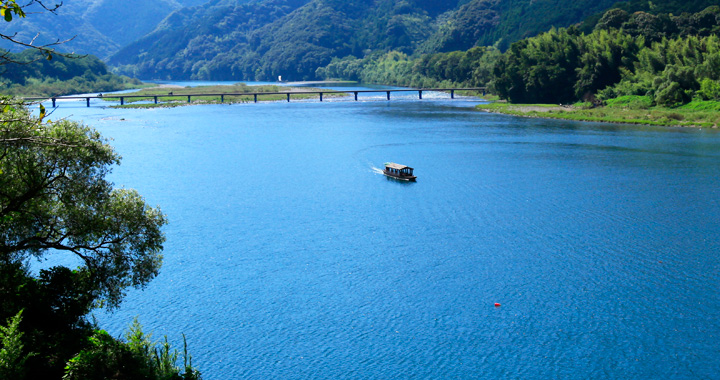
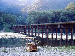
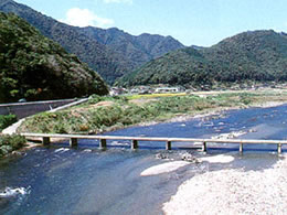
 The longest sinking bridge in the lower reaches of the Shimanto River. As the most well-known sinking bridge it attracts many visitors during the tourist season. 。
Construction date: 1972
Overall length: 291.6m
Width: 4.2m

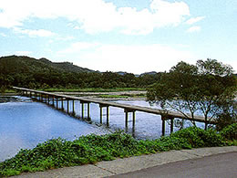
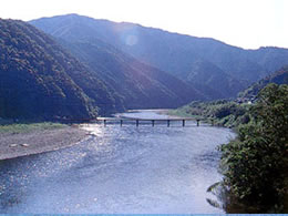
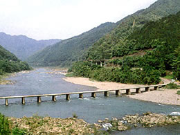
 Despite attracting a smaller number of visitors compared with the Imanari Bridge downstream, the view here at sunset is a must-see.
Construction date: 1963
Overall length:145.8m
Width:3.3m
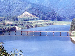
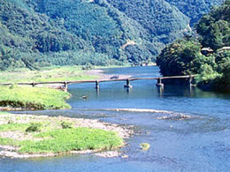
 The third longest sinking bridge on the Shimanto River. Many tourists visit the bridge to enjoy activities such as firefly watching in early summer and camping in mid-summer.
Construction date: 1973
Overall length:232.3m
Width:3.4m
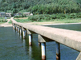
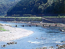
 A rare sinking bridge with three piers. Also used as a location for the movie Tsuribaka Nisshi 14.
Construction date: 1959
Overall length:171.4m
Width:4.4m
 This sinking bridge has a unique design with many curves. The Kurosongawa River, which joins the Shimanto River just downstream from here, is known for having the clearest water among the Shimanto's tributaries.
Construction date: 1955
Overall length:241.3m
Width:3.6m
 The Iwama Sinking Bridge can often be spotted on posters and in TV shows. It is also famous as a spot where tourists pose for pictures.
Construction date: 1966
Overall length:120.0m
Width:3.5m
 This sinking bridge is visited by numerous camping and canoeing enthusiasts during the summer.
Construction date: 1960
Overall length:120.0m
Width:3.1m
 From here you can compare three different bridges: the JR railway bridge, the never-sinking Bassui-kyo Bridge, and this sinking bridge.
Construction date: 1976
Overall length:125.9m
Width:3.1m
 The most upstream sinking bridge in Shimanto City offers visitors with the sights and sounds of the rapids of the fast-flowing stretch of the Shimanto River. During the autumn festival, floats portraying the Japanese legendary creatures Ushioni and Itsushika are carried over this bridge to ward off evil from the area.
Construction date: 1960
Overall length:124.5m
Width:3.3m